Vandaag weer een interessante weer dag op het programma met potentieel (zeer) zwaar onweer, zware windstoten en eventueel grote hagel. Deze buien kunnen erg snel op komen zetten dus het is erg opletten op het water!
Er staat niet veel wind maar toch nog genoeg voor een lichtweer sessie op de twintip of surfboard of een meer dan prima sessie op de hydrofoil.
Hieronder de berichtgeving van het KNMI:
In de middag en avond kans op zwaar onweer"Vanochtend zijn er vooral in het westen en noorden enkele wolkenvelden. Verder is er veel ruimte voor de zon en is het droog. In de loop van de middag neemt van het zuiden uit de kans op onweersbuien toe. Dit kunnen lokaal zware onweersbuien zijn waarbij hagel, zware windstoten en veel regen voor kunnen komen. Voor de buien uit wordt het op veel plaatsen tropisch warm met maximumtemperaturen 30°C of nog iets hoger. De wind is oostelijk en overwegend matig. In de loop van de middag draait de wind van het zuiden uit naar een zuidelijke richting.
In de nacht naar donderdag is het wisselend bewolkt en komen er enkele buien voor die vooral in het noordoosten nog gepaard kunnen gaan met onweer en hagel. Het koelt af naar ongeveer 19°C. Er staat een zwakke tot matige zuidwestelijke wind (Bron: KNMI)."
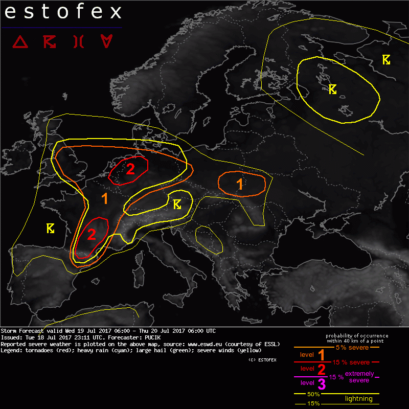
Nog even de voorspelling van Estofex: "A level 2 was issued for N Belgium, Netherlands and NW Germany mainly for severe wind gusts, large hail and excessive precipitation.
... N France, BENELUX, N Germany ...
With the advection of moist airmass from SW and under the mid-tropospheric lapse rates of around 6.5 K/km, basically all models agree on the development of MLCAPE values ranging from 1000 to 2000 J/kg basically over the whole area. MLCAPE values may locally exceed 2000 J/kg especially over Holland and NW Germany, where 2 m dewpoints will likely reach 20 deg C. While degree of instability seems to be supportive of strong updrafts, DLS will range between 10 and 15 m/s, which suggests mostly multicellular storm mode. Shear may increase towards the evening hours with the approach of the trough, particularly in the lower troposphere. Isolated storms may already be ongoing in the morning and early afternoon hours and a rapid increase in coverage is forecast especially over BENELUX and NW Germany ahead and along of the advancing cold front. Storms will likely quickly cluster so that initial threat will be large hail from stronger multicells, followed by excessive rainfall and severe wind gusts from the possible MCS. Large hail threat may be more pronounced towards E, where steeper lapse rates and more isolated storm mode could support stronger updrafts. A lvl 2 is issued for the region with the highest combined risk. "