Een beetje een ander bericht dan normaal maar omdat er tegenwoordig ook veel gefoild wordt toch een waarschuwing. Dit keer voor zeer zware onweersbuien waar hagel, (zeer) zware windstoten en ook eventueel een tornado bij kan zitten. Dus wanneer je het in Zeeland of het IJsselmeer nog op waag houd dan de lucht extreem goed in de gaten...
Hieronder het weerbericht van het KNMI en van Estofex:
Vandaag & morgen
Vanavond enkele onweersbuien, mogelijk met zware windstoten en hagel
Meest bewolkt en plaatselijk wat regen. Van het zuiden uit opklarend. Vanavond trekken enkele zware onweersbuien van zuidwest naar noordoost met (zeer) zware windstoten van 75 tot 100 km/uur, mogelijk zeer lokaal hogere windsnelheden, kans op hagel. Plaatselijk kan veel neerslag in korte tijd vallen. De maximumtemperatuur loopt uiteen van 21°C aan zee tot lokaal 28°C in het zuidoosten. De wind is zuidoostelijk en zwak tot matig. Later op de dag komt de wind uit uiteenlopende richtingen.
Vannacht is er in het noordoosten eerst nog kans op onweersbuien. Er zijn wolkenvelden en de minimumtemperatuur ligt rond 15°C. De wind draait naar zuid tot zuidwest en is overwegend matig.
Woensdag overdag schijnt de zon vooral in het oosten af en toe. In het westen is er meer bewolking en komen enkele buien voor. De middagtemperatuur loopt uiteen van 17°C langs de zuidwest tot lokaal 26°C in het uiterste oosten. Later in de avond kunnen er in het zuiden enkele onweersbuien vanuit België binnendrijven. Er staat een zwakke tot matige wind uit uiteenlopende richtingen. (Bron: KNMI)
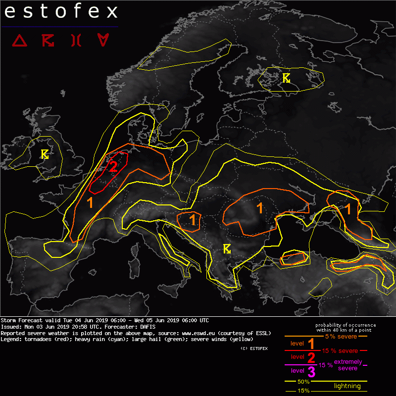
DISCUSSION
.... France, Belgium, the Netherlands, Luxembourg and Germany ....
The approaching trough from the west will be associated with the south-southeasterly flow near the surface, and the veering wind profiles that all available NWP models forecast, will create a dangerous environment for any thunderstorm that will develop. Convective initiation is expected first in Central - NE France after 15z where the PBL mixing ratio is expected to reach values up to 11 g/kg and steep mid-level lapse rates will build large values of CAPE. MLCAPE is forecast to exceed 1.5 kJ/kg inside the level-2 area where more than 15 m/s of 0-3km bulk shear will be available. Storms will be able to quickly form supercells, travelling long distances and producing large hail, severe wind gusts and tornadoes.
The latest outputs of regional models provide different solutions for the convective mode that should be anticipated. If discrete supercells form in NE France and Belgium then the main threat will be large (or very large) hail and tornadoes. If supercells form bow echoes then widespread severe wind gusts will be the main threat.
Given the low predictability of the storm-mode of the storms translating towards Belgium and the Netherlands, it is difficult to exclude any threat. Nevertheless, the high low-level shear of veering winds which create more than 100-150 m2/s2 SREH0-1km and low LCLs, even below 1000 m, mostly inside the level-2 area will increase the probability of tornadogenesis. Convection will become elevated during the night and storms should start weakening before midnight while entering the North Sea.